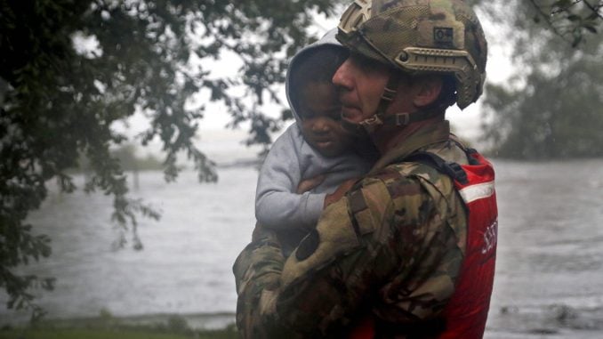
NEW BERN — The Marines, the Coast Guard, civilian crews and volunteers used helicopters, boats and heavy-duty vehicles Saturday to rescue scores of people trapped by Florence’s shoreline onslaught, even as North Carolina braced for what could be the next stage of the disaster: widespread, catastrophic flooding inland.
The death toll from the hurricane-turned-tropical storm climbed to seven in N.C. and one in S.C. Authorities say some other fatalities were unrelated to the storm.
A day after blowing ashore with 90 mph winds, Florence practically parked itself over land all day long and poured on the rain. With rivers rising toward record levels, thousands of people were ordered evacuated for fear the next few days could bring the most destructive round of flooding in North Carolina history.

More than 2 feet of rain had fallen in places, and the drenching went on and on, with forecasters saying there could be an additional 1 1/2 feet by the end of the weekend.
Gov. Roy Cooper and Lt. Gov. Dan Forest both cautioned that the onslaught from Florence was not over. “I cannot overstate it,” said Cooper. “Floodwaters are rising, and if you aren’t watching for them you are risking your life.”
Forest, who spoke to President Donald Trump on Friday, said he told the President, “once the rain is gone and the light shines on some of our hardest hit areas it will probably be worse than expected.” Forest added, “perhaps the worst is yet to come with the flooding still to be seen.”
As of 2 p.m. Saturday, Florence was centered about 50 miles west of Myrtle Beach, inching west at 3 mph — about as fast as a person walks. Its winds were down to 45 mph. With half of the storm still out over the Atlantic, Florence continued to collect warm ocean water and dump it on land.
In its initial onslaught along the coast, Florence buckled buildings, deluged entire communities and knocked out power to more than 900,000 homes and businesses. But the storm was shaping up as a two-part disaster, with the second, delayed stage triggered by rainwater working its way into rivers and streams.
The flash flooding could devastate communities and endanger dams, roads and bridge.
Sen. Harry Brown (R-Onslow) said the storm had caused massive flooding and wind damage in his area. “Please heed the warnings from state and local officials,” said Brown. “If you are in a safe place, stay put until the roads are clear to travel. Flood waters will continue to rise for some time and pose a grave danger. Downed trees and power lines have created additional hazards.”

Duke Energy reported that more than 500,000 customers in North Carolina and South Carolina were without power as of 10am Saturday. Duke has staged more than 20,000 personnel at 39 locations across the two states but, the utility projects that eventually one million and three million power outages will occur across the Carolinas.
Authorities continued to order evacuations in certain areas including the evacuation of up to 7,500 people living within a mile of a stretch of the Cape Fear River and the Little River. The evacuation zone included part of the city of Fayetteville, population 200,000.
Officials in Harnett County, about 90 miles inland, urged residents of about 1,100 homes to clear out because the Lower Little River was rising toward record levels.
One potential road out was blocked as flooding forced the shutdown of a 16-mile stretch of Interstate 95, the main highway along the Eastern Seaboard.
In New Bern, homes were completely surrounded by water, and rescuers used inflatable boats to reach people. More than 360 people had been carried to safety since Thursday night.
The National Hurricane Center said Florence broke a North Carolina rainfall record that had stood for almost 20 years: Preliminary reports showed Swansboro got over 30 inches and counting, eclipsing the mark set in 1999, when Hurricane Floyd dropped just over 24 inches on the state.
As of noon, Emerald Isle had over 23 inches of rain, and Wilmington and Goldsboro had about a foot. North Myrtle Beach, South Carolina, had around 7 inches.
Stream gauges across the region showed water levels steadily rising, with forecasts calling for rivers to crest Sunday and Monday at or near record levels. The Little River, the Cape Fear, the Lumber, the Neuse, the Waccamaw and the Pee Dee were all projected to rise over their banks, flooding cities and towns.
The hurricane center said the storm will eventually break up over the southern Appalachians and make a sharp rightward swing to the northeast, its rainy remnants moving into the mid-Atlantic states and New England by the middle of next week.


