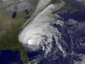

NEW ORLEANS — Tropical Storm Marco began falling apart Monday, easing one threat to the Gulf Coast but setting the stage for the arrival of Laura as a potentially supercharged Category 3 hurricane with winds topping 110 mph.
The two-storm combination could bring a history-making onslaught of wind and coastal flooding from Texas to Alabama, forecasters said.
Still a tropical storm for now, Laura churned just south of Cuba after killing at least 11 people in the Dominican Republic and Haiti, where it knocked out power and caused flooding in the two nations that share the island of Hispaniola. The deaths reportedly included a 10-year-old girl whose home was hit by a tree and a mother and young son who were crushed by a collapsing wall.
Laura was not expected to weaken over land before moving into warm, deep Gulf waters that forecasters said could bring rapid intensification.
“What we know is there’s going to be storm surge from Marco. We know that that water is not going to recede hardly at all before Laura hits, and so we’ve not seen this before. And that’s why people need to be paying particular attention,” Gov. John Bel Edwards warned Sunday at a briefing.
Shrimp trawlers and fishing boats were tied up in a Louisiana harbor ahead of the storms. Red flags warned swimmers away from the pounding surf. Both in-person classes and virtual school sessions required because of the coronavirus pandemic were canceled in some districts.
State emergencies were declared in Louisiana and Mississippi, and shelters were being opened with cots set farther apart, among other measures designed to curb infections.
“The virus is not concerned that we have hurricanes coming, and so it’s not going to take any time off and neither can we,” Edwards said.
Several hours away from the Louisiana coast, a lopsided Marco continued to collapse. By late Monday morning, meteorologists could no longer find tropical storm-force winds within its ragged center. It stayed a tropical storm only because of stronger winds to the northeast.
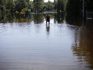
Because of that, the National Hurricane Center canceled tropical storm warnings for west of Morgan City, Louisiana, but kept them for the New Orleans region and farther east to the Mississippi and Alabama border, where Marco still had a bit of strength. The threat of 2 to 4 feet of storm surge remained.
Hampered by strong crosswinds that were decapitating the storm, Marco was expected to lose tropical storm designation late Monday, the hurricane center said.
While Marco weakened, Laura’s potential got stronger, and forecasters raised the possibility of a major hurricane that threatened to pummel western Louisiana and eastern Texas from late Wednesday into Thursday.
Once Laura passes Cuba, the system could quickly strengthen over warm water, which acts as fuel to supercharge the storm. Forecasters predicted winds of 105 mph before landfall, but some models showed an even stronger storm.
Together, the two storms could bring a total of 2 feet of rain to parts of Louisiana, perhaps raising the storm surge to more than 10 feet along the Louisiana coast line and pushing water 30 miles up the rivers in a worst-case scenario, said meteorologist Benjamin Schott, who runs the National Weather Service office in Slidell, Louisiana.
The double punch comes just days before the Aug. 29 anniversary of Hurricane Katrina, which breached the levees in New Orleans, flattened much of the Mississippi coast and killed as many as 1,800 people.
August Creppel, chief of the United Houma Nation, was concerned about the group’s 17,000 members, spread out over six parishes along the Louisiana coast. He took part in a ceremony Saturday at the Superdome in New Orleans that included Native American singing and prayers to commemorate the hurricane’s 15th anniversary.
“I’m very concerned for my people,” he said. “We know our people are going to get hit. We just don’t know who yet.” He’s already been in contact with the Red Cross to get supplies once the weather eases.
For the residents of the Louisiana coast, “they’re certainly lucky that Marco is not worse than it is,” said University of Miami hurricane researcher Brian McNoldy. “This will come and go, and they can get ready for Laura. That’ll be the main attraction.”
On Monday morning, Marco was centered about 55 miles southeast of the mouth of the Mississippi River and heading northwest at 8 mph. Forecasters expected its 50 mph winds to remain just offshore Tuesday as it weakens and dissipates, leaving a flooded coastline.
Meanwhile, Laura drenched much of Cuba as it headed northwest at 20 mph with top sustained winds were 60 mph.
In New Orleans, Sarah Manowitz, responsible for four bars in the city’s French Quarter, saw to it that windows were boarded up. She also battened down her own house and filled her tub with water. She’s remaining on site and counting on a “community of people” who look out for each other during storms.
“We’re all going to help each other share food, share whatever supplies,” she said.